


Precinct 6-2, Red River Parish, Louisiana
About
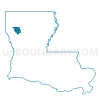
Outline

Summary
| Unique Area Identifier | 590348 |
| Name | Precinct 6-2 |
| County | Red River Parish |
| State | Louisiana |
| Area (square miles) | 4.76 |
| Land Area (square miles) | 4.72 |
| Water Area (square miles) | 0.04 |
| % of Land Area | 99.10 |
| % of Water Area | 0.90 |
| Latitude of the Internal Point | 31.98968550 |
| Longtitude of the Internal Point | -93.30379750 |
Maps


Graphs
Select a template below for downloading or customizing gragh for Precinct 6-2, Red River Parish, Louisiana


Neighbors
Neighoring Voting District (by Name) Neighboring Voting District on the Map
- Precinct 1-1, Red River Parish, LA
- Precinct 5-2, Red River Parish, LA
- Precinct 6-1, Red River Parish, LA
- Precinct 7-1, Red River Parish, LA
Top 10 Neighboring County Subdivision (by Population) Neighboring County Subdivision on the Map
- District 1, Red River Parish, LA (1,436)
- District 7, Red River Parish, LA (1,304)
- District 6, Red River Parish, LA (1,193)